Agencies Mobilize to Improve Emergency Response in Puerto Rico through Better Data
Overview
Federal agencies’ response efforts to Hurricanes Irma and Maria in Puerto Rico was hampered by imperfect address data for the island. In the aftermath, emergency responders gathered together to enhance the utility of Puerto Rico address data and share best practices for using what information is currently available.
Source
Details
Originally published July 26, 2019
Federal agencies responded to the devastation in Puerto Rico caused by Hurricane Irma and Hurricane Maria with a blitz of personnel, food aid, logistics support, and other resources. Their efforts were hampered, however, by imperfect address data for the island. Whether fulfilling the mission to distribute aid after a disaster, enumerate and tabulate the population, or deliver mail on-time, many government entities have a stake in managing Puerto Rico address data in order to meet their respective mission objectives. In the case of hurricanes Irma and Maria, emergency responders did their best to persevere despite this challenge and, in the aftermath, have gathered together to enhance the utility of Puerto Rico address data and share best practices for using what information is currently available. Their efforts serve as a model for other agencies confronting data challenges that inhibit their missions.
A Devastating 2017 Hurricane Season
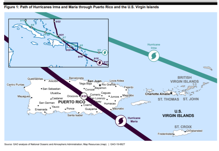
In early September 2017, Irma, a Category 5 hurricane, passed just north of Puerto Rico and the U.S. Virgin Islands, causing damage from wind and rain. Less than two weeks later, Hurricane Maria passed directly over the main island of Puerto Rico, severely impacting all of Puerto Rico. The storm caused a complete shut-down of the power grid, interruption of water supplies, and damage to structures. The resulting flooding and landslides also caused extensive damage to the transportation network, washing out bridges and closing roads all over the island. By the time the major storm and continuing rainfall were over, Puerto Rico had experienced over 42,000 landslides. Repairs are estimated to cost $132 billion.1 Almost 470,000 applications for individual assistance were approved by the Federal Emergency Management Agency (FEMA) following these hurricanes.

Planning for Disaster, Lacking Data
Preparing to respond to the storm damage, FEMA staff realized that the absence of island-wide authoritative address data would require modifying standard geospatial practices and procedures to carry out response and recovery efforts. The large number of un-geocoded addresses (i.e., addresses with no associated latitude and longitude coordinates) and lack of a standard addressing system for parts of Puerto Rico meant that it was often impossible, even through use of aerial photography assessments, to link households filing for assistance to a mailing or location address on the ground, particularly in areas that were inaccessible due to storm damage. These assessments were critical for official determination of households’ assistance eligibility. Local guides accompanied damage inspectors to homes, but with a compromised road network from washouts and landslides, travel to some locations was challenging.
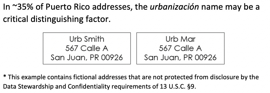
As people registered for assistance, a variety of addressing formats were used within the municipalities, and few were tied to a national address content standard. In some cases, there were complications from the repeated use of street names within an individual municipality. In San Juan, for example, one might find multiple instances of 123 Smith Street, only distinguished by the urbanización they are located in. Urbanización is an identifiable community / housing / neighborhood development in Puerto Rico. But urbanización names were often unavailable, and many applications referenced Post Office (P.O.) boxes, mail stops, and kilometer markers instead of a street address or geographic location. All of these circumstances delayed needed services to survivors in distress.

Organizing for the Next Time
In responding to the storms, FEMA and other agencies adopted a number of strategies to get help where they needed it to be in spite of the limited quality address and location data. While local and national agencies work on assembling and standardizing better address data, a process likely to take several years, agency personnel have convened a number of times to share approaches to getting the most out of existing Puerto Rico data assets.
The White House National Science and Technology Council’s Subcommittee on Disaster Reduction (SDR) hosted the Puerto Rico Address Data Workshop in October 2018, with 39 participants from 12 federal agencies. The workshop featured nine presentations by federal agencies on their data management methodologies and processes for Puerto Rico address data. The U.S. Census Bureau, U.S. Department of Agriculture (USDA), FEMA, Department of Housing and Urban Development (HUD), and the National Aeronautics and Space Administration (NASA) presented insights and lessons learned. Discussions focused on the challenges, successes, and proposed solutions for utilizing and managing Puerto Rico address data. Specific actions from this workshop identified the need to organize a dedicated working group for Puerto Rico address data.2
The workshop provided the impetus for the organization in March 2019 of a formal working group, the Puerto Rico Address Data Working Group (PRADWG), led by the Census Bureau under the auspices of the Federal Geographic Data Committee’s Address Subcommittee. The PRADWG was charged with inventorying and documenting proven practices for managing Puerto Rico address data. The group met regularly over the course of 120 days to discuss and compare data assets, maintenance processes, address data use cases, and proven practices. The PRADWG report, Proven Practices for Puerto Rico Address Data Management, is a result of these efforts.

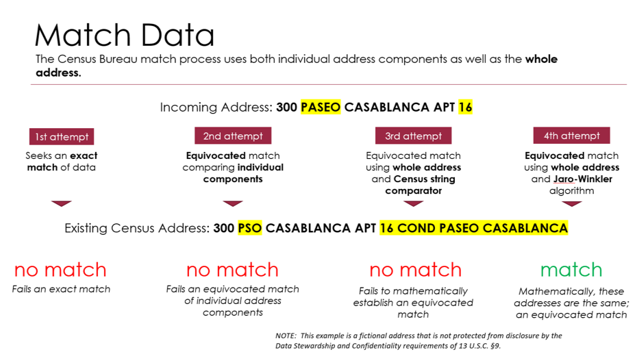
A slide presented at the PRADWG’s kickoff meeting describes the Census Bureau’s approach to matching Puerto Rico addresses with known Census addresses.
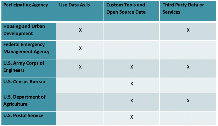
Through the Working Group and subsequent report, agencies like HUD, FEMA, the Census Bureau, U.S. Army Corps of Engineers (USACE), USDA and the U.S. Postal Service (USPS) shared agency solutions and potential opportunities for collaboration within the federal government to manage Puerto Rico address data challenges with existing systems and applications. FEMA, as noted earlier, makes use of local guides and phone calls to homeowners to help find physical locations when data alone does not get them to the right place. Through a series of cleaning and matching strategies, as well as validation against other agencies’ data, the Census Bureau successfully derives useable address locations from its existing Master Address File (MAF), or adds new addresses to the MAF. The USPS regularly updates its Address Management System by feeding in knowledge from mail carriers and its Address Change Service. HUD employs local subject matter experts from a Puerto Rico-based firm to help clean and validate its Puerto Rico address data.

Federal Agencies’ Proven Practices for Address Data Collection and Management
Three proven practices were common to all the federal agencies that participated:
- Recognizing the differences in Puerto Rico addresses and accounting for them in data models used by federal agencies (e.g., adding urbanización name field);
- Standardizing and cleaning the data whether through manual or automated methods;
- Validating the data through fieldwork or a source such as the USPS.
Conclusion
Hurricanes Irma and Maria highlighted the challenges for Federal agencies that rely on residential addresses to supply services in Puerto Rico. Relief efforts during the 2017 hurricane season were hampered by the absence of an island-wide system of addressing and the lack of physical addresses for approximately one third of the island. While it may take several years for Puerto Rico and partner agencies to develop a reliable island-wide address database, there are many tools and approaches that agency officials can take to clean and make use of existing data. The PRADWG and related efforts demonstrate how agencies facing similar data challenges can collaborate to discover and propagate best practices, in turn improving the wider government’s response to disasters and other data-dependent efforts.
Postscript
For more information on the PRADWG and their work read the full report or contact Lynda Liptrap at Lynda.A.Liptrap@census.gov.
Footnotes
To receive updates on activities related to the Federal Data Strategy, please sign up for the newsletter.
The Federal Data Strategy Incubator Project
The Incubator Project helps federal data practitioners think through how to improve government services, enabling the public to get the most out of federal data. This Proof Point and others will highlight the many successes and challenges data innovators face every day, revealing valuable lessons learned to share with data practitioners throughout government.
-
“FEMA’s Disaster Recovery Efforts in Puerto Rico and the U.S. Virgin Islands.” GAO-19-662T: Published: Jul 11, 2019. Publicly Released: Jul 11, 2019. ↩
-
The Puerto Rico Address Data Workshop Minutes and the 2019 Puerto Rico Address Data Inventory are available on the Puerto Rico Address Data Working Group Community Page on the GeoPlatform. ↩
Guidance references
- FDS Practice 01 Identify Data Needs to Answer Key Agency Questions
- FDS Practice 06 Convey Insights from Data
- FDS Practice 09 Connect Data Functions Across Agencies
- FDS Practice 10 Provide Resources Explicitly to Leverage Data Assets
- FDS Practice 18 Manage with a Long View
- FDS Practice 20 Leverage Data Standards
- FDS Practice 25 Coordinate Federal Data Assets
- FDS Practice 28 Align Quality with Intended Use
- FDS Principle 07 Demonstrate Responsiveness
- FDS Principle 10 Practice Accountability

